Your partners in
land preparation
and assessment
Our team of highly skilled experts uses the latest advancements in surveying technology and our proven methodologies to produce rapid, accurate results for any scale of project.
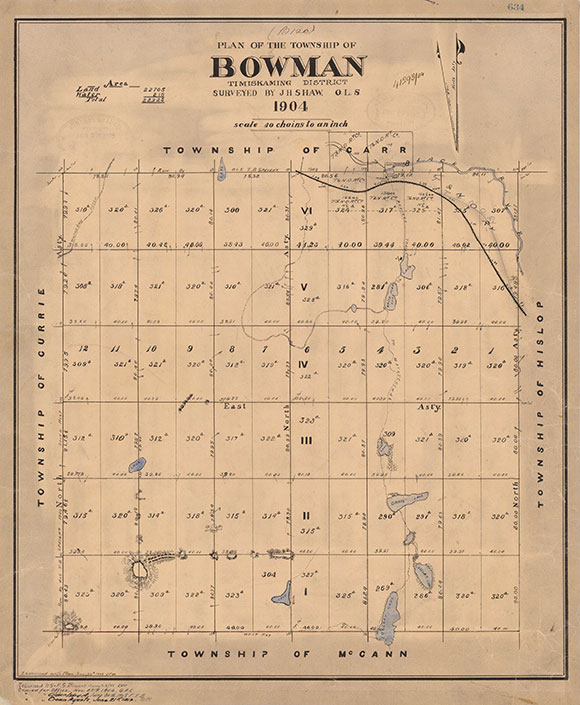
Cadastral Surveying Services
We provide a wide range of cadastral surveying services to support land ownership, legal boundaries, development, and municipal planning:
-
Expert Opinion and Expert Witness Services
Professional testimony and documentation for legal proceedings involving land and boundary disputes. -
Boundary Retracement & Property Line Marking
Re-establishing and clearly marking legal property limits based on historical records and field evidence. -
Plan of Survey
Detailed documentation of property boundaries and features for legal and construction purposes. -
Surveyor’s Real Property Report (SRPR)
A comprehensive report showing property boundaries, improvements, and encroachments. -
Reference Plan (R-Plan)
A legal survey plan used to define part of a property or full of a property for purposes such as severance, easement, land registration, or converting a parcel into Land Titles Absolute or Land Titles Absolute Plus (Absolute +). -
Plan of Subdivision
Legal mapping of newly created lots, roads, and blocks for subdivision development. -
Plan of Condominium / Strata Plans
Surveys for condominium or strata developments, outlining unit boundaries and common elements. -
Expropriation Plans
Surveys for land acquisition by government authorities, including compensation-related mapping. -
Municipal Plans (under Examiner of Surveys Direction)
Preparation of plans in accordance with municipal regulations and land registry requirements. -
Sketches / Descriptive Plans
Illustrative documents supporting legal descriptions. -
Boundary Act Plans
Plans prepared under the Ontario Boundary Act for boundary dispute resolution. -
Correction of Plan
Amending existing registered plans to correct errors or update outdated information. -
Reference Plans for Creating or Lifting Easements / Rights-of-Way
Legal survey plan supporting the creation or removal of rights related to land use or access. -
Water Boundary Surveys
Specialized surveys defining property limits in relation to the ordinary high-water mark or water’s edge for properties with adjoining lakes, rivers, and other bodies of water. -
Cottage Surveys
Boundary and topographic surveys for cottage properties, ensuring accurate title mapping and compliance with specific municipal development requirements.
Surveying Services for Builders
We offer comprehensive surveying solutions tailored to meet the needs of builders and developers at every stage of the construction process — from initial planning through to final occupancy.
Builder’s Package
A complete suite of surveying services designed to support permitting, construction, and final approvals:
-
Initial Plan of Survey
Includes topographic details to assist with design, planning, and municipal approvals. -
Sketches for Legal Descriptions (Draft Reference Plans)
Professional sketches supporting legal descriptions for severances, easements, rights-of-way, and other planning or development applications. -
Site Plan
Detailed layout plan required for permit submissions, zoning compliance, and coordination with consultants. -
Site Grading Plan
Prepared in accordance with municipal grading and drainage requirements to support construction and permit approvals. -
Stakeout for Excavation
Precise field layout marking of proposed building corners prior to excavation. -
Pinning for Footings
Installation of footing pins to guide accurate foundation construction. -
Nails on Foundation
Placement of verification nails on foundation walls to confirm structure alignment. -
Final As-Built Survey
Survey confirming the final location of structures relative to property boundaries and zoning setbacks. -
Final Grading Certificate
Issued upon completion of grading to verify compliance with approved grading plans and municipal standards.

Subdivision & Condominium
Developers Package
At RS Surveying, we specialize in providing comprehensive surveying solutions tailored for subdivision and condominium developments. Our team works closely with developers, planners, engineers, architects, legal professionals, and municipal authorities to ensure projects are completed with accuracy, efficiency, and full regulatory compliance.
-
Preliminary Investigation, Base Mapping & Reference Plan (R-Plan) for First Application
-
Boundary & Topographic Survey
Conduct detailed field surveys to capture existing physical features, elevations, and legal boundaries of the property. -
Encroachment & Easement Identification
Identify any existing encroachments, easements, rights-of-way, and other title-related constraints affecting the site. -
Reference Plan (R-Plan) Preparation
Prepare a legal Reference Plan to support initial applications such as consents (severances), easements, or road widenings, in accordance with the requirements of the Land Titles Act. -
Coordination with Design Team
Provide accurate base mapping and legal boundary information to planners, engineers, and architects to support subdivision design and servicing plans.
-
Boundary & Topographic Survey
-
Establishing and Monitoring Site Control Network (Horizontal & Vertical)
-
Horizontal and Vertical Control Network
Establish a precise and stable on-site control network comprising horizontal and vertical control points. This network forms the foundational framework for all subsequent surveying, engineering, and construction activities. -
Integration with Geodetic Systems
Align the control network with the applicable UTM (Universal Transverse Mercator) or MTM (Modified Transverse Mercator) coordinate system, ensuring full compatibility with provincial and municipal geospatial standards. -
Geodetic Benchmarks
Tie the vertical control to recognized geodetic benchmarks and official vertical datums, such as CGVD2013 or CGVD28, to ensure accurate and consistent elevation data throughout the project lifecycle. -
Monitoring and Verification
Periodically verify and monitor the control network to maintain accuracy and integrity throughout the duration of the project, especially during critical construction phases.
-
Horizontal and Vertical Control Network
-
Preparation of Site Servicing Sketch
-
Site Servicing Sketch
Prepare a detailed sketch showing existing above ground and underground utility information, including but not limited to water, sanitary, storm, gas, hydro, and telecommunication services. -
Data Compilation
Compile servicing data from field observations, existing records, and utility locate reports to ensure a comprehensive representation of all visible and known services on site. -
Coordination with Design Team
Coordinate with civil engineers and utility consultants.
-
Site Servicing Sketch
-
Preparation of Draft Plan of Subdivision
- Collaborate with the developer’s team to design lot layouts, roads, parks, and blocks.
- Ensure the draft plan meets Planning Act requirements and local Official Plan and Zoning standards. Issue Surveyor’s Certificate for frontage, depth and area.
- Prepare Marketing Sketch and Disclosure Plan.
-
Legal and Regulatory Documentation
-
Reference Plans (R-Plans) Preparation
Prepare Reference Plans (R-Plans) to support a variety of applications, including severances, road widenings, and easements, while ensuring full compliance with legal and regulatory requirements. -
Surveyor’s Schedules
Provide all required supporting documentation, including land use descriptions, ownership assignments, and surveyor’s certifications, which are critical for final registration and legal processing. -
Coordination with Authorities
Liaise with the Land Registry Office, as well as municipal and regional legal counsel, to resolve any boundary clarifications, title discrepancies, or related legal matters necessary for successful plan approval and registration.
-
Reference Plans (R-Plans) Preparation
-
Final Plan of Subdivision (M-Plan)
-
Subdivision Plan Drafting and Certification
Draft and certify the Final Plan of Subdivision (M-Plan), illustrating all lot and block boundaries, streets, reserves, easements, and other subdivision features in accordance with the approved draft plan. -
Compliance with Draft Approval Conditions
Ensure the M-Plan satisfies all conditions of draft plan approval, including technical revisions and municipal requirements prior to final submission. -
Monumentation
Monument all corners of lots, blocks, reserves, and rights-of-way to establish legal boundaries on-site. -
Consent and Endorsements
Obtain all necessary signatures and consents from property owners, mortgagees, municipal representatives, and other relevant authorities to validate the plan. -
Registration
Register the finalized and certified M-Plan with the Land Registry Office, completing the legal subdivision process.
-
Subdivision Plan Drafting and Certification
-
Construction Layout & Staking
-
Roads, curbs, sewers, and utilities
Layout of all underground and above-ground infrastructure as per approved engineering drawings. -
Lot corners and house siting
Staking of property corners and house locations in accordance with the grading and site plans.
-
Roads, curbs, sewers, and utilities
-
As-Built Surveys
- Conduct detailed as-built surveys to verify that all constructed features—including houses, roads, curbs, sidewalks, and utilities—conform to approved design plans and municipal requirements.
-
Part Lot Control Exemption Plans
Prepare Reference Plans and supporting documentation for Part Lot Control Exemption applications, where individual lots or units are to be re-divided after the subdivision is registered. -
Final Monumentation & Certification
Install any remaining survey monuments and provide a Surveyor’s Certificate of Completion, confirming that all monuments are in place. This is essential for municipal assumption of public roads and services.
-
Condominium Plans
Condominium plan is considered a form of land subdivision However, unlike traditional subdivisions that divide land into separate lots, a condominium divides property into units and common elements, often in three dimensions.
RS Surveying provides all necessary surveying services and registration support for every type of condominium plan in Ontario. Whether your project involves a standard, vacant land, common elements, or phased condominium, our licensed Ontario Land Surveyors ensure accuracy, compliance, and seamless coordination with your legal and design teams.
Our Services Include:
-
Draft Plan of Condominium
Preparation of detailed draft plans illustrating unit boundaries, common elements, and exclusive-use areas, suitable for review by legal, planning, and engineering teams. -
Final Plan of Condominium
Preparation and certification of the final plan by a licensed Ontario Land Surveyor (OLS), ready for registration with the Land Registry Office. -
Strata (Structural) Plans
Development of vertical or multi-level unit diagrams (Part 3 Plans) for stacked townhouses or high-rise condominiums. -
Disclosure Documentation
Provision of accurate survey drawings and data to support purchaser disclosure requirements during the pre-sale and registration process. -
Declaration Schedules
Preparation of Surveyor’s Schedules, including Schedule C, for inclusion in the official condominium Declaration package. -
As-Built Surveys
Post-construction surveys confirming final unit layouts, elevations, building locations, and installed site features. -
Assumption Surveys
Final site surveys to support municipal clearance and the assumption of shared elements, such as roads, utilities, and common areas.
-
Draft Plan of Condominium

Geomatics Engineering Surveys,
and Project Management Services
We offer a comprehensive range of professional services to support infrastructure, development, and technology-driven projects:
-
Project Management
End-to-end coordination of surveying tasks within engineering and construction workflows. -
Engineering Topographic Surveys
Detailed and accurate mapping for design, planning, and construction. -
Precise Levelling
High-accuracy elevation measurements for critical engineering applications. -
Horizontal and Vertical Control Establishment
Creating geodetic control networks to ensure project precision and alignment. -
GPS/GNSS Surveys
High-efficiency positioning and data collection using satellite-based systems. -
Volume Calculations
Earthwork and stockpile volume analysis for planning and billing accuracy. -
High-Precision Monitoring
Settlement and deflection tracking for structures and infrastructure using advanced instruments. -
Drone Surveying
Aerial data collection and photogrammetry for large-scale or hard-to-access areas. -
Topographic and hydrographic surveys
Map streambeds, waterlines, flood zones and Strom water management Ponds -
GIS Mapping and Analysis
Spatial data processing and interpretation to support decision-making and asset management. -
Bridge site surveys
Including abutment and pier locations, elevation profiles, and structural alignment -
EAT Sector Surveying Services
- Tailored surveying solutions for the Engineering, Architectural, and Technology (EAT) sectors.
- Includes topographic and boundary surveys for infrastructure development, municipal planning, and Ministry of Transportation Ontario road development and construction.
Civil Construction
Surveying Services
We provide expert civil construction surveying services tailored to support projects of all sizes, ensuring accuracy and compliance at every stage.
-
Infill Housing and Civil Construction Survey (Stake, Pin, Nail, and Locate Services)
Precisely marking property lines, building corners, and existing underground utilities (water, sewer, gas, electrical) on infill development sites to ensure proper placement and prevent conflicts with existing infrastructure. -
Earthwork Construction and Grading Survey
Surveying related to earthmoving and shaping, including grading to design elevations and slopes for construction sites, land developments, and golf courses. -
Grade Stake for Proposed Grades (Cut and Fill, Land Design, Golf Course)
Setting stakes at specified elevations to guide earthmoving operations, ensuring proper drainage and landscape shaping by indicating where material is to be cut (removed) or filled (added). -
Volume Calculation and Certification (Stockpile and Excavation)
Accurately measuring volumes of materials in stockpiles or excavations to aid in material management, cost estimation, and project tracking. Using site data to accurately compute volumes of earth to be moved, supported by 3D terrain models for visualization and optimization of earthwork. -
Servicing Pipeline Construction Layout (Storm Sewer and Watermain)
Precisely marking underground utility alignments and connections to ensure proper installation and integration with existing infrastructure. -
Road Construction Layout
Comprehensive surveying for road construction, including centerline, pavement edges, grades, and superelevation (banking on curves). -
Curb and Parking Lot Layout
Marking exact locations and elevations for curbs, parking spaces, drive aisles, and other parking lot features. -
Grid Line Alignment and Cross-Section Layout
Grid Line Alignment: Establishing a consistent, site-wide reference grid essential for all construction activities.
Cross-Section Layout: Marking points across roads, trenches, or other features to define profiles per design requirements.
-
As-Built Survey and Certification
Documenting the final constructed conditions relative to design plans, with certification from licensed surveyors to confirm compliance and support future maintenance or renovations. -
Bridge Layout
Specialized surveying to precisely align and set elevations for all bridge components, from foundations through deck construction. -
Geotechnical Borehole Layouts and Slope Surveys for Stability Studies
Borehole Layouts: Marking exact drilling locations for soil and rock sampling.
Slope Surveys: Mapping ground slopes to assess stability and identify risks, critical in landslide-prone or heavily modified areas.
-
High-Rise Building Layout
Transferring architectural designs of high-rise buildings to the field with high precision by establishing exact locations for columns, walls, elevator shafts, and key structural elements using advanced tools.

Specialized Survey Consulting
We offer expert consultation and reporting services tailored to assist property owners, developers, legal professionals, and municipalities with land-related decisions, applications, and dispute resolution.
Expert Opinion & Expert Witness
Providing authoritative, unbiased professional opinions and expert witness testimony in legal matters related to boundary disputes, title issues, and land use conflicts.
Municipal Applications
Preparation and support for municipal submissions including:
- Part Lot Control Exemption
- Lot Severance (Consent Applications)
- Minor Variance Applications
Land Title Absolute Applications (First Application Process)
Advisory and support services for converting properties from the Registry System to the Land Titles System. Guidance through the "First Application" process including preparation of required plans, reports, and declarations.
Easement and Right-of-Way Creation or Lifting
Surveying and legal consultation for the creation or removal of easements and rights-of-way, including documentation, sketches, and registration support.
Property Description & Deed Diagram
Preparation of accurate and legally defensible property descriptions and deed sketches for use in conveyancing, registration, and title correction.
Real Property Buyer and Seller Specialty Reports
Due diligence reports for real estate transactions, providing clarity on property boundaries, encroachments, easements, and compliance with zoning and site conditions.
Grading Plans & Certificates
Design and certification of grading plans to comply with municipal engineering and planning requirements, often used in building permit and occupancy processes.
Contact Us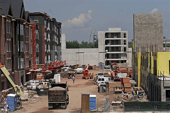
Land Information Systems &
GIS Mapping
Our team specializes in creating and managing geospatial data systems that integrate, analyze, and visualize land-based information. We turn complex datasets into actionable insights that support better planning and decision-making.
Contact Us
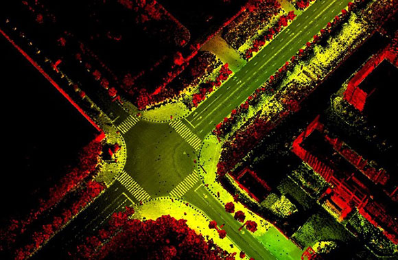
Reality Capture by Drone,
Lidar Scan and USV
Using cutting-edge drone imaging, lidar scanning, and unmanned surface vehicles (USVs), we provide highly detailed 3D data and imagery for a wide range of applications. Whether you're modeling terrain, inspecting structures, or conducting hydrographic surveys, our reality capture services deliver precision and efficiency.
Contact Us
“
RS Surveying are doing a 23 acres condo project for us in Alliston, ON. He also did some custom home projects for us. They did the project with high professional standards. Educates us during work, keep us posted and fellow the timeline. I will highly recommended to hire them. ”
– Zafar Ahmad